 PA Media
More heavy rain is set to lash parts of the UK in the coming days after thunderstorms hit many areas on Saturday.
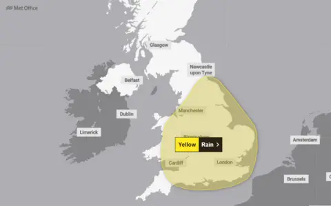
Further yellow weather warnings for rain have been issued by the Met Office for Sunday – the day of the autumn equinox marking the end of summer – and Monday.
They cover large parts of southern and central England, and Wales on Sunday, and gradually stretch towards northwards and eastwards before expiring at 23:59 BST on Monday.
Thunder, lightning, hail and rain struck various parts of the country on Saturday, including Luton, Bedfordshire, St Albans in Hertfordshire, and Cornwall, with heavy downpours in London, Wales and Birmingham.
Into next week
On Sunday, the Met Office is warning of surface water issues and travel disruption due to heavy rain, urging people to take care if out and about or travelling.
Its meteorologist Becky Mitchell said the weather will be “unsettled” at the start of the week, with the potential for more localised flooding.
Heavy rain will continue into Monday, spreading further across northern and eastern England, with power cuts, flooding of homes and businesses and delays to train and bus services possible, the Met Office said.
The south-west will be drier and turn brighter later in the day and the weather will become drier for some areas further north but patchy rain will move into the north of Scotland.
 met office
Forecasters expect temperatures to dip on Tuesday, but a lot of the wet weather will clear and some sunny spells will develop across the north and the south.
Wet and windy weather will return to southern areas on Wednesday. Elsewhere it will be dry but cloudy.
Scotland, Northern Ireland and areas around the Irish Sea are expected to experience calmer conditions during this period.
Those areas will have plenty of sunshine and pleasant temperatures but it won’t be long before the autumn chill arrives.
Autumn equinox and beyond
Just days ago, many people were enjoying warm sunshine in the UK, but summer will officially end on Sunday.
‘Meteorological autumn’ starts on 1 September every year whereas ‘astronomical autumn’ begins at equinox which is on 22 September this year.
The word “equinox” is derived from Latin and literally translates to “equal night”.
On these days, everywhere on Earth experiences roughly 12 hours of sunshine and 12 hours of darkness.
With cooler weather coming, a change of wardrobe will soon be inevitable for all of us.
Next week, daytime temperatures will typically range from 12C in Scotland to perhaps 16C along the south coast of England. By the middle of the week, there is a chances of gales and colder, northerly winds.
Keep up with our latest thoughts on the coming weeks with our monthly outlook.

